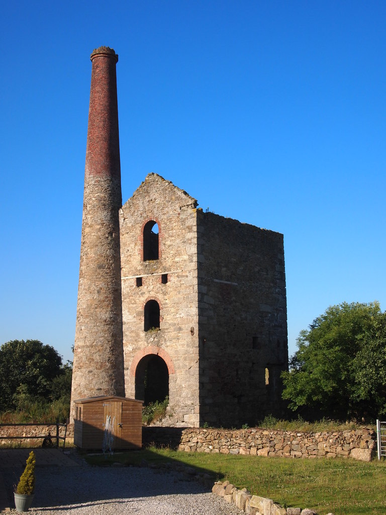
North Treskerby
Copper, Arsenic, Tin, and Pyrite Mine
Worked from old to 1882
Jan 1st, 2024 from RF by Buddle-Bot
![]() | |
Cornwall | |
Redruth | |
50.262249, -5.195879 | |
SW 7232 4514 | |
Private Land | |
128m | |
#8,712 |
See also: Truan (Trewan) Mine. Appears as two separate groups of workings on the surface, but they are connected underground by a crosscut at deep adit level. The western section lies just north of Wheal Briggan, situated on the east side of a northwestward-flowing stream, also forming the western boundary of the mining area. Here, the focus was mainly on two lodes: the Main lode and the South lode, both trending ENE approximately 250 yards apart. Most of these workings are now covered, except for a significant dump east of the road to Scorrier (Treseder’s shaft) and some smaller dumps southwest of Wheal Rose village.
In the eastern part of the mining area, along the road leading to Skinners Bottom, the eastward extension of the Main lode was exploited. The coordinates provided are for Doctor’s shaft in this eastern section, with its engine house serving as a prominent landmark. Between 1859 and 1882, the mine yielded a total of 19,270 tons of copper ore with an average grade of 6.3%, along with smaller quantities of black tin, arsenopyrite, arsenic, and pyrite. After 1875, it was amalgamated with Scorrier Consols.
old 1859-1882
Publications (3)
- (1920); BGS - Mineral Resources of GB (c1920s) Vols XIV, XV, XVI, XVII, XVIII - Fireclay; Arsenic & Antimony Ores; Refactory Materials, Lead & Zinc of Scotland, Rock-Salt and Brine (5 books); 777 pages
- (1923); BGS - Mineral Resources of GB (c1920s) Vol XXVII - Copper Ores of Devon and Cornwall; 92 pages
- Dines, Henry George (1956); BGS - Regional Memoirs - Metalliferous Mining Region of South West England Vol1, The; 567 pages
Doctor's Shaft - 10m
George's Shaft - 172m
John Michael's Shaft - 219m
East Downs - 299m
Jack's Shaft - 319m
East Truan - 321m
Truan Mine - 404m
Scorrier Consols - 465m
Flatrod Shaft - 476m
Pininger's Shaft - 494m
Highburrow Shaft - 531m
West Briton, Wheal - 550m
Rose, Wheal - 553m
Read's Shaft - 581m
Hallenbeagle - 604m
West Truan - 663m
Hawke, Wheal - 748m
Owla, Wheal - 765m
East Chance, Wheal - 791m
Boscawen - 843m
Briton, Wheal - 859m
Vreah, Wheal - 898m
Butcher's North Shaft - 899m
Pendarves - 961m
Concord, Wheal - 984m
Briggan, Wheal - 991m
Lemon's Shaft - 1,009m
Scorrier Wolfram - 1,014m
East Treskerby - 1,020m
Great North Downs - 1,066m
Chance, Wheal - 1,087m
Wright's Shaft - 1,125m
Davey's Shaft - 1,132m
Trewan North - 1,142m
Widden, Wheal - 1,143m
North Hallenbeagle - 1,166m
Tregullow Consols - 1,193m
Black Dog Shaft - 1,201m
Buckingham's Shaft - 1,229m
Trevethan Shaft - 1,264m
Footway Shaft - 1,277m
Great Briggan - 1,280m
North Busy, Wheal - 1,303m
Stencoose and Mawla - 1,341m
Messer, Wheal - 1,397m
Gimp - 1,441m
Richard's Shaft - 1,441m
Old Treskerby - 1,448m
Ann, Wheal - 1,482m
Killifreth - 1,515m
New Shaft - 1,519m
Treskerby and Wheal Chance - 1,528m
Moor, Wheal - 1,537m
Drainage Adit - 1,542m
Old Sump Shaft - 1,561m
Victoria, Wheal - 1,591m
Previous, Wheal - 1,591m
Great Busy, Wheal - 1,617m
Plenty, Wheal - 1,664m
Union, Wheal - 1,670m
Old Sump Shaft - 1,694m
Pryor's Shaft - 1,705m
Vor Shaft - 1,714m
Derrick, Wheal - 1,743m
Boys, Wheal - 1,744m
Sir Frederick's Engine Shaft - 1,783m
Peevor, Wheal - 1,791m
Harvey's Shaft - 1,882m
Unity Wood, Wheal - 1,889m
East Ellen, Wheal - 1,895m
Little North Downs - 1,967m
Drive - 1,982m
North Downs - 1,983m
Stony Shaft - 1,984m
Carnhot - 1,999m