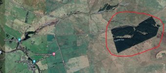
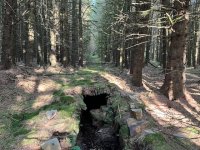
Is there an adit in these woods ??

Big-G

Member
Hi All :)

Hope someone can help me with this one please......

I was having a mooch round Whitesyke and Bentyfield today, and I was sure I'd seen somewhere that there was an adit in the woods marked on the pic ??

However.....with very limited internet on my phone up there, and the fact I was knackered after two days of trawling the lead mines and reservoirs of Teesdale, I couldn't be @rsed to search the whole woods for it :cry:

Is there an adit in there, or have I got the wrong wood ?? :unsure:

Cheers,
Graeme.

Garrigill.JPG
 
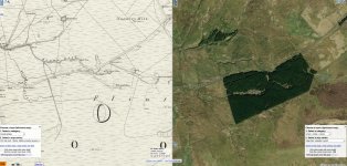
Yup, should be. I Can't speak for the location accuracy as yet as I've not surveyed it myself. - oops, piccie to big... try again!
 
Yes, it appears so!
Bugger…..why didn’t I think of using the old maps (a combination of sunstroke, and being knackered) !! :rolleyes:

Mind you…..I didn’t have me glasses with me…..I could barely see my phone, let alone anything on the screen !! 🤪

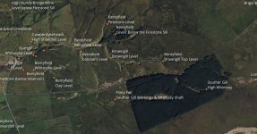
I’m sure I’ve seen a pic of the adit somewhere online, but I can’t seem to find it now I’m looking for it…..anyone got a pic of it please ?? I think it might be a long surface run in, in a bit of a clearing ?? :unsure:
 
souther gill.jpg

Screen grab from the North Pennines dBase I've been compiling. I can't speak for the accuracy of the location as I've not surveyed and validated the locations/names shown yet. That's the next few years work :D (And the Coal Authority have been mucking around at a number of places up there too)
 
View attachment 937

Screen grab from the North Pennines dBase I've been compiling. I can't speak for the accuracy of the location as I've not surveyed and validated the locations/names shown yet. That's the next few years work :D (And the Coal Authority have been mucking around at a number of places up there too)
I hate blowing sunshine up peoples’ @rses but…..that’s awesome !! Wish I’d had access to that today (as well as me glasses !!)

The coal Authority were up there today, leading a group who had something to do with funding ?? And I got talking to a guy called Ryan on the other side of the main road to Whitesyke. He was surveying the grasses and flowers, where the project to reduce metal pollution was done. They’ve done a great job up there.
 
It's taken months to compile the first pass, it'll take years to visit and get proper grid refs and see what's left (if anything) at some sites. but, keep watching the forum for some announcements
 
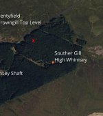
Do you have an accurate Grid Ref for it, that way I can update the record I've got for it (which is off to the west on the other side of the road!). I can pull a visual estimate from your pin, but if you've a grid ref to hand, all the better. (DM me if you want).

The biggest problem I've had so far in compiling an initial list (2000+ features between a66 & a69, & a68) is that the quality of the locations/grid refs quoted by sources is pretty poor 😢. Consistent/accurate naming is a close 2nd ☹️
Using Wheres the Path, the adit is on the the OS, ref I get from that is NY 76589 42295
 
Using Wheres the Path, the adit is on the the OS, ref I get from that is NY 76589 42295
I've just looked at what I've got recorded, and to give you some idea of the poor state of the record, I've two other entries for that level neither of which agree with each other. One of them is from the English Heritage/Historic England Scheduling listing. None are even close to the position you've given.

Thanks for your update (y):cool:
 
Thanks guys, had to give it a miss as I was on my own & the car decided to do some odd stuff when overtaking a peloton of cyclists - something weird with the clutch and engine management - a bit of a smell when I got to Garrigil. So decided to play it safe & stay on main & level roads instead of the climb over to Nenthead. Seems to have been OK on the way home, so I'm relieved at that!

Appreciate the warning on the shafts & I'll defo' take the camera along too next time I'm nearby.
 
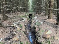
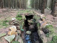
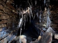
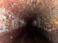
I was in the area today, so had a pop into the plantation to try and find the adit. After a few laps of the woods, and a few scrambles through the trees, I finally found it 🙂. It’s a great looking adit, set in an amazing place. And whoever dropped the pins on the maps…you were spot on. Thanks 👍😉
 

Attachments

  • IMG_0062.jpeg
    IMG_0062.jpeg
    255.8 KB · Views: 32
  • IMG_0063.jpeg
    IMG_0063.jpeg
    252.2 KB · Views: 33
  • IMG_0066.jpeg
    IMG_0066.jpeg
    173.2 KB · Views: 33
  • IMG_0070.jpeg
    IMG_0070.jpeg
    137 KB · Views: 31
  • IMG_0073.jpeg
    IMG_0073.jpeg
    234.7 KB · Views: 32
Back