You are using an out of date browser. It may not display this or other websites correctly.
You should upgrade or use an alternative browser.
You should upgrade or use an alternative browser.
Pike Law
- Thread starter PeterJ
- Start date
Jim MacPherson
Member
Hi Pete,Jim - some interesting plans have come to light in the Raby Castle archive. Nick Unwin has been helping Colin Fowler to relate these to current land surface - using GIS methods.
I mentioned that to Don when I emailed him back, certainly the snippets Colin has sent on look fascinating, it's good the archivist at Raby is so keen to continue delving.
Jim
The plans are interesting, but frustratingly sparse on features we can use to fix to the location. I've had to work more to shape, rotation & scale to get an initial fit, then try and improve it by looking for patterns or possible alignments of shaft distances, but there're so many surface workings, in so many stages, at Pike Law that it's difficult to say for certain if we've achieved any real alignment when looking at various satellite imagery sets. There're several possibilities. Need to take a look onsite now to see what's real, what's shadow/phantom, & what's wishful thinking , and to see if there are traces of any portals in the areas indicated as likely.
Jim MacPherson
Member
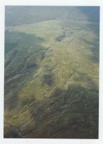
On a nice sunny, warm day (there are a few, honest) the site is a great place to spend an unhurried day wandering about, have you had sight of the drone footage that was taken, among other things it gave some interesting images of truncated gullies above West End Hush? , v.late hushing or landslip perhaps, Colin may still have access to it, one of the site's difficulties is it's general flatness and therefore lack of vantage points, there are one or two places to the northwest above Leonard's Hush give some limited perspectives, good views over towards Flushimere House and other places. There's also odd bits of LIDAR and some of the RAF's wartime piccies were quite useful.The plans are interesting, but frustratingly sparse on features we can use to fix to the location. I've had to work more to shape, rotation & scale to get an initial fit, then try and improve it by looking for patterns or possible alignments of shaft distances, but there're so many surface workings, in so many stages, at Pike Law that it's difficult to say for certain if we've achieved any real alignment when looking at various satellite imagery sets. There're several possibilities. Need to take a look onsite now to see what's real, what's shadow/phantom, & what's wishful thinking , and to see if there are traces of any portals in the areas indicated as likely.
Jim
Thanks Jim - I don't have access to the earlier drone footage, but that's not too much of an issue as I'll be doing my own full aerial survey & topographic model once I get a chance to get up there. I'd hoped to join Colin & Pete on their next visit but unfortunately I've another engagement that dayOn a nice sunny, warm day (there are a few, honest) the site is a great place to spend an unhurried day wandering about, have you had sight of the drone footage that was taken, among other things it gave some interesting images of truncated gullies above West End Hush? , v.late hushing or landslip perhaps, Colin may still have access to it, one of the site's difficulties is it's general flatness and therefore lack of vantage points, there are one or two places to the northwest above Leonard's Hush give some limited perspectives, good views over towards Flushimere House and other places. There's also odd bits of LIDAR and some of the RAF's wartime piccies were quite useful.
Jim
I do need to find some Lidar data as that might help to show the real shaft tops from the imaginary 'hollows' that shadowing on the satellite images creates. I'll see if I canfind the RAF aerial images too, 50+yrs has a way of hiding things from view.
Colin has an idea where a portal may have lain, and the bits I've laid out fall within about 60-100ft of his region - hopefully something from our wanderings there in the next month or so may give us the 'Aha!' moment
Jim MacPherson
Member
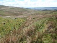
Just checking how straight forward it is to show a photo, I had to compress it a bit but this is from above Leonard's Hush looking down the spillway with the dressing floor in the mid-distance and some of the boulder lines from the miniscule dam but I hope Flushimere House is clear enough looking towards Newbiggin. As I commented getting panoramic views over the site is not too easy.
Jim
Jim
Attachments
Thanks for posting that Jim, you aren't helping me scratch the itch to get up thereJust checking how straight forward it is to show a photo, I had to compress it a bit but this is from above Leonard's Hush looking down the spillway with the dressing floor in the mid-distance and some of the boulder lines from the miniscule dam but I hope Flushimere House is clear enough looking towards Newbiggin. As I commented getting panoramic views over the site is not too easy.
Jim
Getting panoramic views is easier these days now we have access to drones as the ability to get up a-height really helps. I've also got a 7.5mm wide angle rectilinear lens that I can fit on one of my drones & which gives wonderful wide angle shots - it's about the equivalent of 15mm on a 35mm SLR camera. The rectilinear nature helps reduce wide angle distortion at the edges too.
Just need some time, and some decent, non-wet, non-windy days now... not many of them this time of year in Teesdale & Weardale
The 1m DTM lidar can be downloaded from https://environment.data.gov.uk/surveyThanks Jim - I don't have access to the earlier drone footage, but that's not too much of an issue as I'll be doing my own full aerial survey & topographic model once I get a chance to get up there. I'd hoped to join Colin & Pete on their next visit but unfortunately I've another engagement that day. Once I've done the survey I can highlight a few likely points for shafts to check out again on the ground. There're also a couple of potential clues in the notes written on the plans, but again I'd like to get boots on ground and see if any suppositions tie in first. It's easy to make suppositions looking at a computer screen which are obviously absurd once you're at a site.
I do need to find some Lidar data as that might help to show the real shaft tops from the imaginary 'hollows' that shadowing on the satellite images creates. I'll see if I canfind the RAF aerial images too, 50+yrs has a way of hiding things from view.
Colin has an idea where a portal may have lain, and the bits I've laid out fall within about 60-100ft of his region - hopefully something from our wanderings there in the next month or so may give us the 'Aha!' moment
Defra Data Services Platform
Looks like it will be split across NY83se and NY93sw i've been looking at something a valley further west so already have it downloaded

Jim MacPherson
Member
It's a fascinating site with shafts/bell pits in weird places, leats that seem wildly over-engineered and bits of structures that have rather unclear purposes, all it really needs is rather obsessive type to put up with generally rubbish weather/conditions to wander about the place for a long time. In addition Brian Young and co are now of the view that quite a lot of the hushing remains may well be linked to glacier/ice cap retreat, it would have been interesting if that could also explain the rock 'gate' into the western end of West End Hush
Churchill's comment about a riddle wrapped in a mystery surrounded by an enigma seem quite apt.
Jim
Churchill's comment about a riddle wrapped in a mystery surrounded by an enigma seem quite apt.
Jim
I think the view on glacial retreat is mainly for the higher & larger Coldberry Hush to the east. The maps we're looking at only reference a single hush, not the larger number that are named on the site today - the implication being they're of later origin. It would have been easier to locate if they were shiwn! I think the Pike Law Hush & the others being of later origin also explains why there's such a problem finding a suitable string of shaft heads to line up with - they've been obliterated by the hushing & subsequent workings.
Thanks for the link Chris... I'll download it when I get a chance although, looking at the bit you've uploaded, it's not going to help us much Damn
Damn 
Thanks for the link Chris... I'll download it when I get a chance although, looking at the bit you've uploaded, it's not going to help us much
Jim MacPherson
Member
Nick is the single hush you refer to sometimes called Derbyshire Gentleman's Hush on a couple of the earliest maps which could be Flask Hush or possible the most southerly arm of Pike Law Hush though both contain the notorious boulder lines that Brian seems confident are remains of human mining activity, certainly the regular 'walling' like sections on the line just south of Leonard's Hush makes that quite probable.I think the view on glacial retreat is mainly for the higher & larger Coldberry Hush to the east. The maps we're looking at only reference a single hush, not the larger number that are named on the site today - the implication being they're of later origin. It would have been easier to locate if they were shiwn! I think the Pike Law Hush & the others being of later origin also explains why there's such a problem finding a suitable string of shaft heads to line up with - they've been obliterated by the hushing & subsequent workings.
Thanks for the link Chris... I'll download it when I get a chance although, looking at the bit you've uploaded, it's not going to help us muchDamn

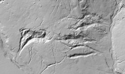
One useful aspect of Flask is that it's relatively uniform in cross section (as per the LIDAR view from Chris) so arriving at a 'reasonable' guess for the amount of waste matter derived is at least plausible the others are more difficult and developing the erosive power from the dams to remove the debris would have been quite a challenge even over the 100/150 years of possible hydraulic activity. Although I think Ray Fairbairn is of the view that hushing as a significant activity had finished by 1800-20 and I think the first known map showing a named hush is about1730 so the highly erosive phase is possible about 60- 70 years. At one stage we rather hoped lichen dating might give some more clues but the rabbits chewed that idea up.
Jim
Jim, it is the DG's hush. I don't think it's Flask Hush as denoted on the maps, but rather that it's probably the lower eastern most section of the Flask & Pikelaw hushes that runs nw-se towards flushiemere beck. If it's not that, then it's the lower section lying just to the North of them. I'd hoped to find some shaft head patterns to confirm it, but there're too many possibilities still so we need to look for other clues as to the how far to adjust the positioning n-s.
I'm not always convinced by 'hushes' marked on maps, I think some have just been denoted as that by later surveys and may often have just been open worked, or are natural features with some minor working having taken place.
Rabbits, best kept in hutches and pies .
.
I'm not always convinced by 'hushes' marked on maps, I think some have just been denoted as that by later surveys and may often have just been open worked, or are natural features with some minor working having taken place.
Rabbits, best kept in hutches and pies
Jim MacPherson
Member
That photo supports the lines I've been thinking along  . However, I still want to get boots-on-ground and do some GNSS mapping & measuring on ground and in the air to confirm a few things that may help narrow the field down better - basically to do with heights of various bits of the site. Hopefully I'll end up with a solid model something like the one I've done of Middle Greenlaws . (That one's not geo-referenced, just roughly accurate as I had limited gear with that day.)
He was & unfortunately that's one of the dates I can't make Pete ... got a meeting with an ex-RAF image analyst 


