Sharnberry Knocking Stones

ElectroNick

Active member
Hi Everyone,

There where 3 Knocking Stones recorded as being present at the Upper Sharnberry site when they where listed back in 1987. However, when I tried to find them a week or so back to get some photos to add to the Missing Pieces Project, I couldn't locate then at the Grid Ref specified. Unfortunately, Historic England don't have any photos linked on their listing page, and a google searh hasn't turned anything up either - Has anyone ever seen them since their listing date, and does anyone have any photos of them (before or after listing)?

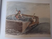
Knocking wall at lead mine ore-dressing floor. Probably early C19. Ashlar blocks. 2 large blocks c.0.2 metre high, 0.6 metre back to front and 0.5 metre across, forming shelf; a third, dislodged, on ground nearby. 2 wooden pegs prop rubble packing stones below front edge of blocks. Shelf worn just behind front edge by blows of hammers dressing ore. A rare example of part of an early ore-dressing floor.

Cheers
 
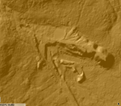
Maybe a long shot but LiDAR ?


Or wait until the peak of summer . It’s amazing how much the water table changes the surface growth and appearance.
 
Mmm, 40yrs of moss & tall heather growth is probably sending them back to being a bit of heather moorland. Probably as well as it'll protect them - provided they're still there somewhere. I've a feeling they'll probably not have been seen since the listing recommendation was made to be honest - 3 stones in the middle of nowhere
 
Hi Everyone,

There where 3 Knocking Stones recorded as being present at the Upper Sharnberry site when they where listed back in 1987. However, when I tried to find them a week or so back to get some photos to add to the Missing Pieces Project, I couldn't locate then at the Grid Ref specified. Unfortunately, Historic England don't have any photos linked on their listing page, and a google searh hasn't turned anything up either - Has anyone ever seen them since their listing date, and does anyone have any photos of them (before or after listing)?


Cheers
A fave place of mine Sharnberry....but I'm embarrassed to say I don't know what "knocking stones" are ?? :giggle:. And a Google search didn't really help :unsure:
 
To the best of my knowledge, they were hard stones/surfaces on which lead ore was placed and then broken into smaller chunks & waste removed by whacking them with a hammer. Ie an early form of crushing mill/stamps worked purely by brute force.
 
To the best of my knowledge, they were hard stones/surfaces on which lead ore was placed and then broken into smaller chunks & waste removed by whacking them with a hammer. Ie an early form of crushing mill/stamps worked purely by brute force.
Thanks for that…..sounds good to me 👍🙂
 
To the best of my knowledge, they were hard stones/surfaces on which lead ore was placed and then broken into smaller chunks & waste removed by whacking them with a hammer. Ie an early form of crushing mill/stamps worked purely by brute force.
Also known as bucking stones or buckstones. The ones I've seen have one or more noticeable depressions worn into the surface on which the ore was broken. There's an easy one to find by the open works at the top of Bwlch y Plwm mine at Llanfrothen.

Dave
 
I became a bit dubious about some parts of HE write-ups when we were doing the Oresome project certainly at Pikelaw they seemed to be using a stock format to explain the site remains, including the infamous horse-gin circles, we must have wasted a lot of hours wandering about many of the shaft tops searching for some evidence and, sadly, found none, similar phrases were used on a couple of the other sites. Aspects of Feldon smelt mill's descriptions are slightly fantastical as well. Bah humbug.

More positvely Tom's point about LIDAR is very useful certainly for older abandoned sites where the slow creep of time has buried what little remains, walls and expecially linear features seem to stand out rather well.

Jim
 
Unfortunately, while I can generate highly accurate aerial models & create DSMs, I don't have access to any lidar equipment so have to rely on footwork (aka falling over, or off, the bloomin' things 🤪.)

The early English Heritage "legacy' listings are frustratingly limited in the info they recorded/made available, and a fair bit of what they do record gives conflicting info/locations/descriptions. I think the modern 'custodians' share some of the frustrations as they can't always find more detailed info on the reason for listing either as they're lost in 'legacy' records.

One reason for asking if there are photos anywhere is that there is a possibility of a single suitable stone on one of the nearby dumps. It's kind of the right'ish dimensions, but is some distance from where it should be if it were one... and stones don't magically grow legs & wander off on their own :oops:. It's also recently been used by someone as a knocking stone to break some stone as there are bits of freshly broken fluorite on top it. Unfortunately we didn't have anything to use to take measurements with us at the time, so can't be sure it's the right size as reported on the listing - it's probably just be a nice random stone. Next visit +1 for taking a measure with us.

As to Feldon, there ain't much to see above ground these days other than the flue bed and base of the chimney. I did fly an aerial survey of it back in 2016-17, before my current interest in Lead Mining was piqued, but it's not to my current level of detail. I've gathered sheep, walking and driving through it in doing so several times over the years! Need to revisit it and include the wider area as there are more building outlines in other parts not covered by the scheduling.
 
  • Like
Reactions: Heb
I know the LiDAR maps are constantly getting updated with higher viewing capabilities, I think the one my mate uses is now 50cm ?

Have you checked all the old Ariel photograph databases ? Some times you find building footings in the dry summer images etc.

Just a thought :)

I am by no means a stone expert ! Possibly more a ochre expert haha
 
Nick

The 'Britain From Above' site has a good HD photo taken in the 1940's (?) from a bit west of Edmondbyers looking up the valley to the mill, it looked largely complete at that time, I've got a copy somewhere and Colin F may recall sending me the link some years ago.

Jim
 
I know the LiDAR maps are constantly getting updated with higher viewing capabilities, I think the one my mate uses is now 50cm ?

Have you checked all the old Ariel photograph databases ? Some times you find building footings in the dry summer images etc.

Just a thought :)

I am by no means a stone expert ! Possibly more a ochre expert haha
I’ve had a look at the area already and saw nothing that fits the description on LiDAR, but it’s hard to know exactly where to focus on. It’s best to correlate LiDAR with boots on the ground.
 
Nick

The 'Britain From Above' site has a good HD photo taken in the 1940's (?) from a bit west of Edmondbyers looking up the valley to the mill, it looked largely complete at that time, I've got a copy somewhere and Colin F may recall sending me the link some years ago.

Jim
Cheers for searching that out Jim, that view is so familiar and incredibly similar to today, although Harehope has a few more barns attached now and of course the intake reservoir has been built since too. There doesn't look to be much more of the mill visible than today though - the ruins in the middle are still there, but the smelt mill & flue is to the left of them. I've a private source I'll tap to see if they have any old photos and if there's anything noted on deeds.
 
I’ve had a look at the area already and saw nothing that fits the description on LiDAR, but it’s hard to know exactly where to focus on. It’s best to correlate LiDAR with boots on the ground.
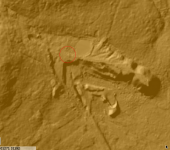
supposedly within the circled area if you go by the listing.

1715157800568.png
 
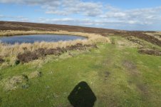
the area they're meant to be in...9030_211_7220.jpg

I've had a wander through the heather bit (and a section to my left too), but didn[t manage to fall over/off, or twist my foot on, anything 😟

We did manage to not get chased away by the 10 or so grumbling greylag geese though 🤣
 
Back