Tyne-Tees-Transfer Tunnel

ElectroNick

Active member
Does anyone have any freely accessible information on the Keilder-Tees Transfer Scheme where it runs between Derwent and Eggleston?

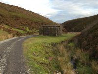
I went for a somewhat windy stroll to Sharnberry yesterday and came across a strange building on the way down the Gill - turns out it's part of the long white-elephant water transfer tunnel that was bored between Riding Mill and Eggleston. That in turn set of a memory of a comment by Fairbairn in Mines of Upper Teesdale for Sharnberry, and which set me wondering if the TBM had encountered any old lead mining works along the route, or if it had managed to avoid everything? The route it takes passes through areas with lots of workings around Frosterley (and it must go very close to Rogerley), and southward through Bollihope-Sharnberry-Blackton on its way to Eggleston. Fairbairn eludes to some info on the mineralogy from the tunnel boring, but doesn't enlarge on it much.

I've found a couple of references on the web, but they're behind paywalls :( One being CS McCulloch's paper, and another being Jamie Ion's site with a few photos and a map of the route.

TIA
I'm sure it gets a few mentions in Dunhams (Vol1), I seem to recall there is at least one mention of a known vein/fault being cut by the works.

From the preface to the second edition - The Northumbrian Water Authority, through their Engineering Consultants Babtie Shaw and Morton generously permitted the examination of mineralised intersections before the concrete lining of the Tyne-Tees tunnel system took place; Mr D A C Mills collaborated.


The Little Whin Sill was recorded to the N of Stanhope in the western workings at Stanhopeburn Mine, which reached the Three Yard Limestone. In the Northumbrian Water Authority tunnel, what was probably a continuation was found in an upward transgression 8917 ft (2718 m) S of the River Wear portal.
 
How freely accessible?
Northumberland Archives hold a lot of the records relating to the scheme inlcuding plans, photos etc. No idea if any have been digitised but access is free.
 
I shall offer a moderately unhelpful bit, I have a couple of photos taken in the 1970's of my Dad and others about to go in to one of the mouths (Frosterly perhaps), at present I can't find them but I rather think it was an organised trip, unsure again but it was something like 'The Conclomerate Association/Society' the name may well be incorrect as I can't see any internet trail leading to that name.

As I say not much use, I may find the photos they were on definitely AN but I've not managed anything on 'Way Back Machine' if it was an organisation then they may have trip records somewhere, perhaps others on here recall the name. All a bit of a long shot but who knows.

Jim
 
So, looking at OS mapping, the high pressure part of the system from Riding Mill to Airy Holm Reservoir is easy to trace due to regular inspection shafts.
The position of the interconnect with the Derwent tunnel is known so plotted where it is said to be (though that seems strange as there is no inspection shaft at that point). Wakerley Air Shaft position can be plotted exactly
Though plotted directly to the Frosterley Outfall the route is almost certainly slightly West and not as straight.
South of this to Eggleston Outfall my quick look didn't reveal anything conclusive though there are some linear markings which could be related, again West of the straight line shown. Didn't check LIDAR


Contains OS data © Crown copyright 2021

Anything on the BGS website? I seem to recall they had some tunnel geography section diagrams.
 
The Sharnberry Air Shaft is a known position too -> NZ 00718 30731 . I think a friend that farms up Derwent way might have some 'old' maps with more details on, I seem to recall him mentioning something about a water tunnel once, but I'd thought he was meaning an East-West pipe, and earlier than the 1970's. I'll have to see if he's still got the maps.
 
I thought the water was planned to actually flow along the river wear as part of its course
 
I thought the water was planned to actually flow along the river wear as part of its course

Drifting away from the original question a bit more but interesting background - Designed to provide up to 2 cumec transfer to the Wear at Frosterley for drought alleviation in the river.
 
Is this your “strange building” ??

It’s a pleasant walk along to Sharnberry :)


View attachment 597
Yes, that's the one. It's not something you'd expect to find up in the back-end of nowhere. Seems they where all built to a similar design style as it's like the ones up from Riding mill.

It is a very pleasant walk to Sharnberry down the gill although It was a bit of a wind tunnel a couple of days ago, but the Grouse made up for it with some wonderful fast flights 😎

I did a bit of research into that building, as I thought it looked out of place where it was. That lead me on to researching the whole Kielder Dam project and water transfer tunneling system. An amazing piece of engineering all round. The old pics of the construction of Kielder Dam, and the flooding of the area, is well worth a Google ;)

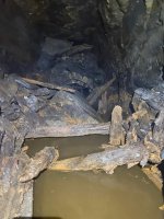
Without wishing to take over the thread, has anyone been into Sharnberry ?? It looked very uninviting when I was there :(
It's not the most pleasant of places. Deep water, ochre and shale collapses. IMG-20200909-WA0034.jpg
 
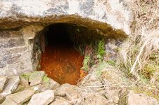
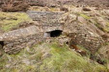
It doesn't look the most inviting, that's for certain & the water looked rather ochre on Friday. I think the Coal Authority is looking to do some work there as it's been tagged with causing pollution into the Wear - the portal is dammed to provide some water sampling/flow monitoring.

The whole area was gently dripping & it looked like there'd been some recent overhang collapses in bits to the south side of the track. It didn't look like the most pleasant or stable area to work.

6314_109_2299.jpg6314_109_2272.jpg
 
Sharnberry is one of the adits that is regularly monitored by EA to sample water quality. CF and I were inside one day when the monitoring team found that they were collecting rather red water samples.
 
Sharnberry is one of the adits that is regularly monitored by EA to sample water quality. CF and I were inside one day when the monitoring team found that they were collecting rather red water samples.
Hi Peter,

How long ago was that, if you don’t mind me asking ?? And how far could you get in, what were conditions like, and do you think you could get that far in now ??

Cheers,
Graeme.
 
So, looking at OS mapping, the high pressure part of the system from Riding Mill to Airy Holm Reservoir is easy to trace due to regular inspection shafts.
The position of the interconnect with the Derwent tunnel is known so plotted where it is said to be (though that seems strange as there is no inspection shaft at that point). Wakerley Air Shaft position can be plotted exactly
Though plotted directly to the Frosterley Outfall the route is almost certainly slightly West and not as straight.
South of this to Eggleston Outfall my quick look didn't reveal anything conclusive though there are some linear markings which could be related, again West of the straight line shown. Didn't check LIDAR


Contains OS data © Crown copyright 2021

Anything on the BGS website? I seem to recall they had some tunnel geography section diagrams.
Bgs you can sort of follow the line with the bore holes info
 
Back